How Water Works (And Why It Matters)
Caltech scientists and engineers on campus and at JPL, which Caltech manages for NASA, use satellites and seismic monitors to track the planet’s most important resource—water—and build miniature river systems in the lab to expand society’s understanding of the water cycle amid climate change, droughts, and wildfires.
BY KER THAN
This past July, the news was awash in reports of European towns and villages devastated by a cataclysmic flood. The raging waters enveloped homes, uprooted trees, and turned roadways into rivers of mud and debris. As he watched the images from his home in Pasadena, Christian Frankenberg spotted familiar places from his childhood. He grew up near the German city of Bonn, about a dozen miles from the Ahr Valley, a lush wine-making region that suffered some of the worst flood damage.
“I hiked the area quite a few times as a kid, so it literally struck home for me,” says Frankenberg, who holds a joint appointment as a professor of environmental science and engineering and a JPL research scientist. “It’s a narrow little valley, so it’s always been prone to floods, but not to this degree. The water level was something like two meters higher than the previous highest water level. I thought, ‘This is crazy.’”
Frankenberg absorbed the news of the floods with dismay but little surprise. After all, he researches how Earth’s global carbon cycle interacts with and is influenced by its water cycle, the path water follows as it moves between the ocean, land, and atmosphere. This work helps to demonstrate how the frequency of extreme weather events is increasing because of climate change. As floods grow heavier and hurricanes stronger in some areas, droughts worsen in others, a portent of freshwater scarcity becoming one of the defining issues of the 21st century.
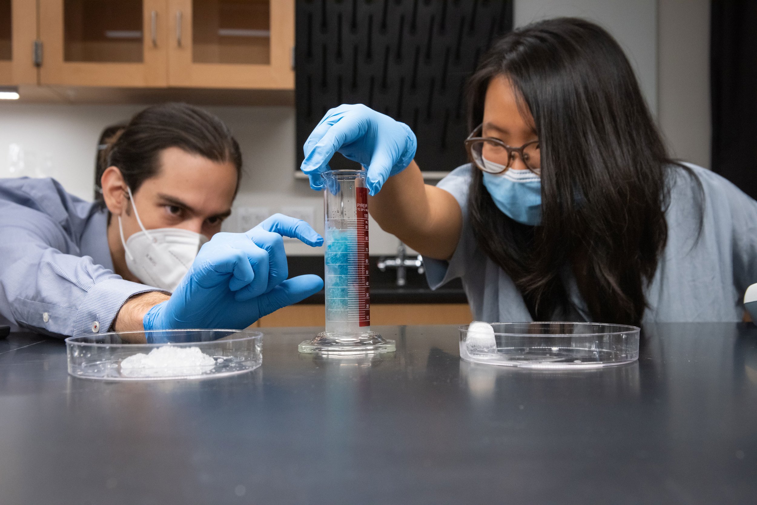
Graduate student Nathan Jones (left) and Ruby Fu, assistant professor of mechanical and civil engineering (right), use dye to analyze the fluid dynamics of water as it flows through lab-created snow. Credit: Lance Hayashida/Caltech
Frankenberg tries not to be too affected by climate news, but scientific objectivity can be elusive when floodwaters drown your childhood playground or when your home state wages a continuous battle against wildfires exacerbated by chronic drought conditions and water shortages. Across Caltech, campus and JPL scientists and engineers who measure and monitor the planet’s water find themselves in a similar place.
Mark Simons, the John W. and Herberta M. Miles Professor of Geophysics and JPL’s chief scientist, and his team have used satellite radar to track how the ground in Southern California rises and falls like a breathing giant as water is pumped into and out of aquifers. “My primary interest was understanding what makes earth move across different time scales and the underlying mechanics that control this movement,” he says. “But this is an example where what I know how to do can potentially be useful to society.”
Spurred by curiosity and a fresh sense of urgency, researchers from the Institute’s divisions, including JPL, and from interdisciplinary endeavors such as the Resnick Sustainability Institute (RSI) use every tool at their disposal to study and track Earth’s water and to understand the vast energies and materials that water conveys. Their research draws on satellites in space and optical fibers deep underground, on advanced computer simulations and miniature, lab-built rivers. Their findings are filling gaps in our knowledge of Earth’s hydrological cycle and improving the management of our most precious resource.
Their discoveries might also help prepare us for the tumultuous decades to come.
Coupled Cycles
Water is a primary factor that affects the extreme weather events connected to climate change. “It’s seen as one of the dominant drivers of global warming in the future,” Frankenberg says. “Ideally, with new climate models we can produce better statistical estimates for how extreme events might change in the future.”
Frankenberg is helping to build one of those next-generation climate simulations through his work with the Climate Modeling Alliance (CliMA), which includes scientists, engineers, and mathematicians from campus, JPL, MIT, and the Naval Postgraduate School. CliMA aims to construct a new kind of model of Earth’s land, oceans, and atmosphere that uses space- and ground-based planetary observations to predict droughts, heat waves, and extreme rainfall events more accurately than ever before.
The CliMA group’s work demonstrates why accurate climate forecasts require a deep understanding of how climate change affects the water cycle and vice versa. For example, changes to the water cycle can drive changes to cloud cover in the atmosphere and snow cover on the ground, both of which affect Earth’s albedo, or surface reflectivity. Higher albedo means more solar radiation is reflected into space, which helps cool the planet.
The connectedness of the global carbon and water cycles is another part of this research. In March, Frankenberg and former Caltech postdoctoral scholar Vincent Humphrey published a paper in Nature showing how the amount of water present in soil affects surface temperature and humidity, which in turn affect plants’ ability to absorb carbon dioxide emissions. “Here we have a smoking gun,” says Humphrey of the finding. “We can say with confidence that soil moisture plays a dominant role in the year-to-year change we see in the amount of carbon taken up by the land.”
Modeling Snowmelt
Every summer, the snow that has accumulated atop California’s Sierra Nevada mountains during the winter slowly melts. Water trickles into streams, rivers, and reservoirs to irrigate farms in the state’s fertile Central Valley, where much of the nation’s fruit, nuts, and vegetables are grown, and to provide drinking water for millions of people from the San Francisco Bay Area to Southern California.
This same alpine process occurs around the world to provide water for billions of people. Yet science’s picture of snowmelt is incomplete.
“A lot of the snow science that has been done is about observing snow from space,” says Ruby Fu, an assistant professor of mechanical and civil engineering. “But that only gives you a 2-D picture. It’s really challenging to monitor the depth of snow from space, but that depth is the dimension where a significant part of the snowpack hydrology takes place.”
“The Mississippi River wasn’t dug by a bulldozer.”
In 2013, JPL launched an airborne mission to fly remote-sensor-equipped airplanes over the Sierra Nevada to measure how much water the mountains hold and provide these data to water managers. The project was so successful that it has been spun off into its own company, Airborne Snow Observatories. Now Fu’s team wants to address the same problem at a more fundamental level. “I’m looking at snowpack physics and trying to understand how snow in the Sierra Nevada melts and how it contributes to our hydrological systems in California,” she says.
To accomplish this, Fu’s group will create a miniature snowpack in the lab and then study it as it melts. “It’s one of the craziest things I’ve ever decided to do,” Fu says. A simple version of the experiment would be to substitute a block of ice for snow, but as Fu explains, “a block of ice melting is like caramel melting in your mouth. It’s different than watching a snowpack melting, because a block of ice is not porous the way snow is.”
Instead, she plans to create individual icy particles and have them accumulate into a pile of snow-like structures that can more accurately represent what happens when meltwater percolates through a snowpack and alters the snow structure in the process.
“I thought that it would be really useful if we could recreate a snowpack in the lab and actually watch it melt and then model the melting process,” Fu says. “A better predictive model of how a snowpack becomes water could lead to better real-time water control by water managers, who need to know how much meltwater to expect.”
Artificial Rivers
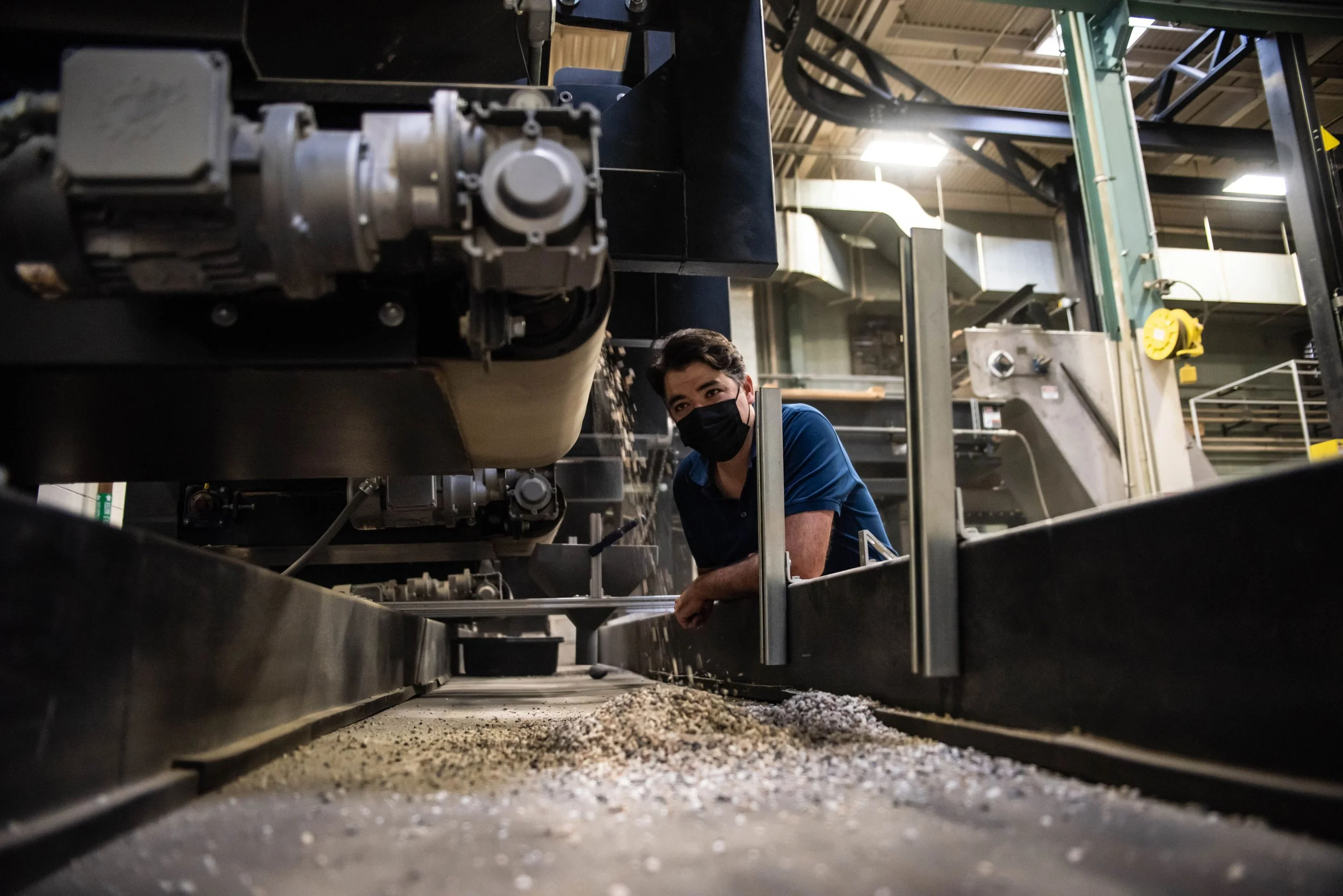
Professor of Geology Mike Lamb oversees work in the Caltech Earth Surface Dynamics Laboratory, where his team builds artificial rivers to simulate natural processes. Credit: Lance Hayashida/Caltech
Fu is not the only one working to create natural environments in the lab. In a 4,000-square-foot warehouse called the Caltech Earth Surface Dynamics Laboratory, also known as the Flume Lab, located in the southwest part of campus, a model river flows toward a miniature ocean. Sediments carried by the water settle along the river’s bottom and are deposited at its mouth to form a familiar fan-shaped delta. But whereas a real delta might take hundreds of years to form, this one begins to appear in months.
This is hydrology in miniature. The artificial delta spans only a meter or two at its widest point, and the tiny river that feeds it measures about 15 centimeters wide, 1 centimeter deep, and 5 to 6 meters long. The entire river system has been meticulously crafted by Professor of Geology Mike Lamb and his group inside the Flume Lab. “We have flumes similar to what you might have seen at science museums, where you can play with water and sediments, but at a more sophisticated level,” he says.
Lamb’s bespoke waterway allows his group to watch a delta develop more quickly, but the process still requires six months or more. “Although we can speed up time, we can’t speed it up too much because we’re trying to study the physics of how water flows and how sediments move in these systems. If we make it go too fast, we start to violate the conditions that occur in nature,” he says.
Lamb’s group employs these artificial water channels to study processes such as when a river changes its path, called an avulsion. A river avulsion usually occurs when an accumulation of sediment raises the riverbed relative to the neighboring land, making the river unstable. “Our artificial deltas display similar behaviors to what we see in nature,” Lamb says. “A river channel will be going in one direction out to the ocean but eventually becomes unstable and jumps course. That is an avulsion.”
It is crucial to understand avulsions because these course corrections can be sudden and violent, triggering catastrophic floods like the 1887 Yellow River flood and the 1931 China floods, which are estimated to have killed a combined 6 million people. By modeling avulsions in the lab, Lamb hopes to understand how they happen, where they might occur next, and how they might be affected by climate change.
For example, one of the group’s latest experiments, detailed last summer in the journal Proceedings of the National Academy of Sciences, examined how river avulsions are impacted by a rising sea level. “Theories predict that the frequency of avulsions will increase with rising sea level and that avulsion locations will shift upstream under certain conditions,” Lamb explains. “Those results bear out in our experiment, so it gives us some confidence that our computer models are getting the physics right.” Lamb also works on real-world deltas as a coinvestigator on JPL’s Delta-X project, which uses the Mississippi River Delta as a natural laboratory. Led by JPL scientist Marc Simard, Delta-X combines airborne remote sensing with on-the-ground measurements to study the delta’s water, vegetation, and sediment. Although the airborne instruments can see overall sediment concentration, they do not penetrate the water to see sediment close to the riverbed.
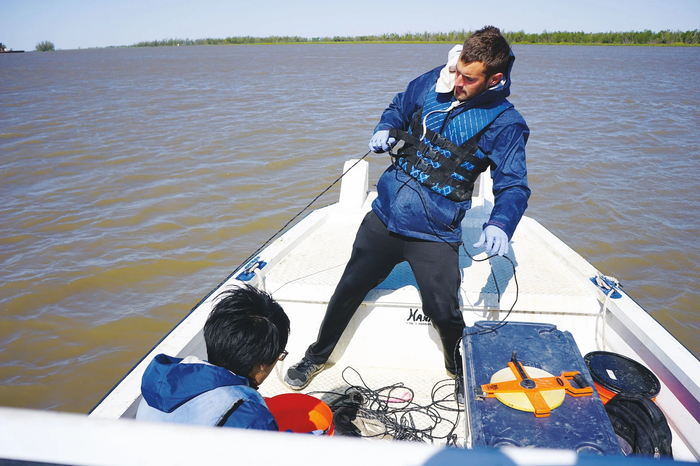
That is where Lamb’s team comes in. “We’re ground truthing. We’re going out in a boat and measuring water and sediment fluxes and comparing that to the remote-sensing data,” he says.
The goal of this research is to predict how the Mississippi River Delta will respond to a rising sea level, to find out which areas are most vulnerable to storms, and to forecast which parts of the delta will grow or disappear. “The Mississippi River wasn’t dug by a bulldozer,” Lamb says. “It has a certain size and depth, and it meanders and bends its way across the landscape, and much of that is determined by how the water moves sediment and where the sediment ends up.”
Data Deluge
The story of the 21st century in the American West has become a story of drought. The past 20 years were the driest 20-year period since the 1500s in the region spanning Oregon to Mexico in the north-south direction and California to Colorado from west to east. A severe dry spell in the early 2000s was followed by record-breaking
droughts in 2012 and 2016. The West is mired in drought again this year, and each new year brings the possibility of an extreme wildfire season worsened by the lack of rainfall.
“Over the course of studying these droughts, NASA realized two things: that we can really get a good handle on what’s happening from space, and that this is the beginning of something bigger,” says JT Reager, a research scientist in JPL’s Surface Hydrology Group. During these recent decades, NASA scientists were among those who demonstrated that the same factors that alter Earth’s atmosphere also change its water cycle. The agency has responded to this information by launching an array of satellites that now form the backbone of science’s ability to track the planet’s water.
Caltech postdoctoral scholar Gerard Salter retrieves a water sampler from the Wax Lake Delta while Caltech graduate student Justin Nghiem (MS ’21) readies the sample bag. Samples are analyzed for suspended mineral sediment and particulate carbon to predict land loss in the Mississippi Delta region as part of the JPL-led Delta-X project. Credit: Mike Lamb
“We have more information streaming in now on water than we’ve ever had at any point in human history,” Reager says. “NASA has several satellites up and several more that are going to be launching in the next five to 10 years.” This includes a mission to study and track rain and snowfall, surface waters, and drought. “JPL has an observation of almost every component and every flux of the hydrological cycle,” Reager says.
NASA generates so much data about water that it has become a major challenge to integrate the many streams of information into a single tributary from which to draw useful and actionable insights. “That’s what we do all day: think of ways to connect different data sets,” Reager says. He collaborates with Fu and others on campus on a project that uses data science and machine learning to seamlessly combine different data sets, whether they are gathered by satellites, airplanes, or boats.
In the future, some of that data could come from surprising places. For example, Assistant Professor of Geophysics Zhongwen Zhan (MS ’08, PhD ’13) aims to study water using underground optical fibers originally laid down for communications and which he previously used to study earthquakes. Zhan’s team will use a new technology called distributed acoustic sensing (DAS) to monitor groundwater beneath Owens Lake in California, a mostly dry lake that the state hopes to revive by refilling the groundwater basin beneath it. DAS will convert fiber-optic cables around the lake into sensitive seismic arrays that scientists can use to measure the injection, withdrawal, and movement of groundwater under the lake.
“We have more information streaming in now on water than we’ve ever had at any point in human history.”
“We want to see if we can basically throw all that data into a cauldron and try to understand some critical questions,” says Simons. For example, how can scientists direct and track water that has been reinjected into the ground? Can we improve our understanding of the interactions between ground and surface waters so we can learn how to best replenish underground reservoirs?
A World of Water
Both efforts to combine different water data sets—the DAS monitoring project and Fu’s snowpack research— are funded by seed grants from RSI, which advances global sustainability through transformational science, engineering, and education. “RSI is interested in understanding the basic science and engineering that can help us progress to a more sustainable society, and it’s clear that one aspect of sustainability is access to fresh water for drinking, agriculture, and other uses,” says Simons, who leads RSI’s Water Resources initiative.
A geophysicist by training, Simons followed a meandering path to study water. “When we look at these measurements of Earth, it’s inescapable that the dominant signal sometimes is not tectonics but hydrology,” he says. Simons now seeks to adapt technologies he has used to study earthquakes and other seismic events to his investigation of water. For a 2018 study, for instance, his team used a satellite radar technology called interferometric synthetic aperture radar (InSAR) to track terrain changes across the Los Angeles Basin and the Santa Ana Coastal Basin that were caused by pumping water out of the ground. His team now uses the same technology to look at terrain changes caused by groundwater pumping in the San Gabriel Valley, where campus and Lab reside. The data will be shared with local water agencies to help them better understand their aquifers.
“We’re not water managers,” Simons says. “All we can say is, ‘Here are some observations about your water resources. Now take this and fold it into your decision-making process.’”
Simons sees even more opportunities for research efforts from campus and Lab to inform how water is managed and monitored around the world. “If we can help people in developing nations better understand their aquifers, that’s just as important as what we’re doing in a place like California, where there are a vast number of other resources that can be used to understand the aquifer system,” he adds. “My hope, and my intent, is that we take a global perspective to addressing these challenges in sustainability.”


